One Step Beyond:
BeLaVi Westallgäu
Precisely dated, laminated lake sediments contain an amazing wealth of archaeological background data. If the palaeoenvironmental, palaeoeconomic and palaeoclimatic information they contain can be exactly synchronized to waterlogged archaeological evidence from lake shore sites, a dataset on human activities in landscapes far beyond the lake shores is generated.
This is the core outcome of the Degersee research project completed in 2010, focusing on a small lake in South Western Germany. The Degersee project, which was co-financed by the German Science Foundation (Pl95/48-1) triggered not only a whole series of new discoveries, but also the design of the tri-national Beyond Lake Villages - Project (BELAVI), which was also financed by the German Science foundation, started in 2015.
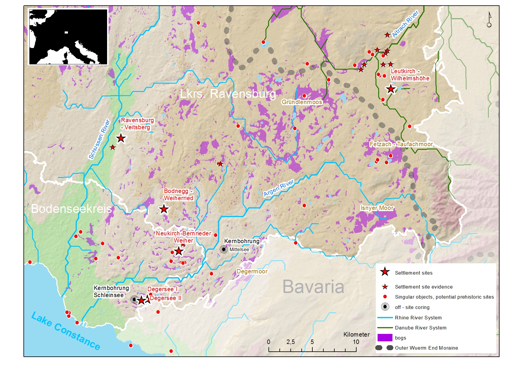
The German working – group, organized within the Landesamt für Denkmalpflege Baden-Württemberg, consists of 12 scientists and undergraduates. Its working area is Western Allgäu, a sub-mountainous region between Lake Constance and Schussen river valley to the west, and the border of Bavaria to the South and East. The Main European watershed subdivides the region in two hydrological units, Danube and Rhine systems. Topographic and hydrological models illustrate that in the Holocene the landscape was characterized by a mosaic of woodlands growing up on moraines and drumlin rows, surrounded by an entanglement of lakes, bogs, channels and water courses.
Archaeological assessment – beyond conventional “pile dwelling” archaeology - includes not only lakeshore and wetland sites, but also sites on hilltops, in mineral soils and in colluvial deposits at the hill-flanks. Archaeologigical perspective focuses on the landscape beyond the singular site, with "culturul landscape" understood as a concept with two complementary components, the terrestrial cultural landscape and the aquatic cultural landscape. Archaeological investigations were carried out in three different scales - regional, in "micro-regions", and on a site level. Archaeological on-site investigations, due to the large investigation area and the large number of potentially prehistoric sites were restricted on very small "key holes".
Hic sunt leones - discoveries in a hitherto unknown archaeological landscape
Until recently the Westallgäu, from an archaeological point of view, was terra incognita, with only singular objects on the archaeological map. After one year of archaeological surveying we have knowledge of several newly discovered settlement sites, dating between 4300 BC and 300 BC, including lake shore -, bog - , and a hilltop site. Trackways made of stone and of timber have been surveyed, and numerous new sites with singular objects or potentially prehistoric datation could be mapped. At this stage of work two clusters of sites dominate the map: one in the region at the lower courses of Argen and Schussen rivers, the other in the river valleys of Aitrach and Eschach near Leutkirch / Allgäu, which are tributaries of the Iller / Danube rivers. The picture provokes questions on the role of the water courses, watersheds, and the relation of land and water transport in the communication system of that time.
The lake shore settlement of Degersee II
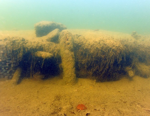
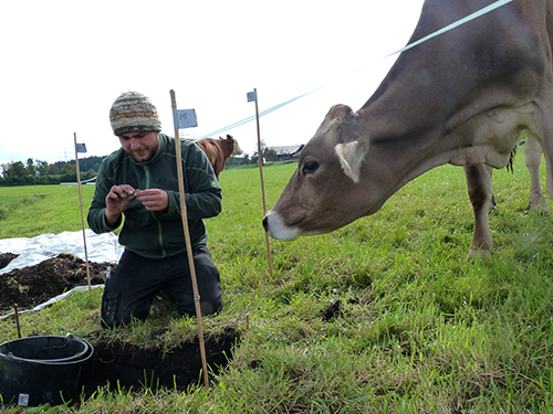
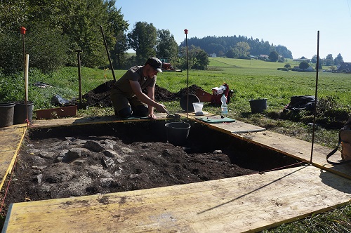
One focus of 2016 field work was at Degersee, a small lake in the hinterland of Bodensee. We now know three neolithic lake shore sites at the northern shore of the lake, dating between 3985 BC and 2956 BC (radiocarbon and dendro dates). In Degersee II, which dates to the beginning of final Neolithic (ca. 3300 BC) trenches were opened in the context of a underwater cliff (fig. below) and in the adjacent wetlands as well. One of the eye-catching results of the field work are distinct indicatios illustrating that there was a specialized flax production in the site.
Photograph: Courtesy LAD / W. Hohl
Photograph: Courtesy LAD / M. Erne
The bog settlement at Neukirch-Bernrieder Weiher
Near Neukirch, some 15km north Degersee, house floors and culture layers of another site of the Younger Neolithic were uncovered. Datations are not available yet, but objects and archaeological evidence suggest that we dicovered another site of 4th millenium BC. Today the area is in use as meadows and pastures.
Photograph: Courtesy LAD / K. Teichmann
The bog settlement of Bodnegg-Breites Ried
The site of Bodnegg is situated on peat deposits in the center of a former lake. The stratigraphy includes two man-influenced deposits, one dating to the beginning of the 4th millennium BC, the other - according to preliminary dates - to the middle of 5th millennium BC. With the infomation available so far, the lower layer indicates one of the oldest neolithic sites we know from the whole south - west German pre-alpine forelands. Clay floors and fire places of the top-most layer were again met directly below the sods of the pastures and meadows covering today the former bog. All observations indicate that the site is severely threatened by oxygen access to former water-logged organic evidence.
In Bodnegg, house floors and fire places made of clay and pebbles are situated directly below the sods of the meadows and pastures. Photograph: courtesy LAD / M. Mainberger
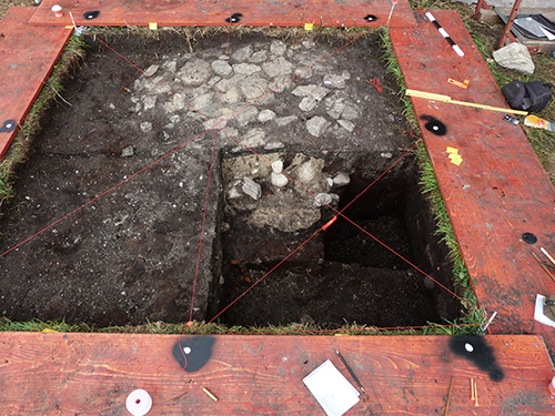
The picture shows th fireplace made of stone and clay in profile. Photograph: courtesy LAD / K. Teichmann
The hilltop settlement of Leutkirch - Wilhelmshöhe
High above the river valley of the Eschach culture deposits were discovered in pits. Radiocarbon dates and ceramic sherds date the site to the end of the 5th millennium, with its culture formations "Aichbühler Gruppe" or "Schulterband" Groups. The site represents a whole cluster of Neolithic sites at the edges of the river valleys of Eschach, Aitrach and Wurzacher Aach that have hitherto been only known as hunter-gatherer activity zones.
The site at Leutkirch, as several important other sites, has been discovered by Franz Hau / Leutkirch-Hofs. Photographs show dark sediments embedded to the mineral soils at the top of "Wilhelmshöhe". Photograph: courtesy LAD